


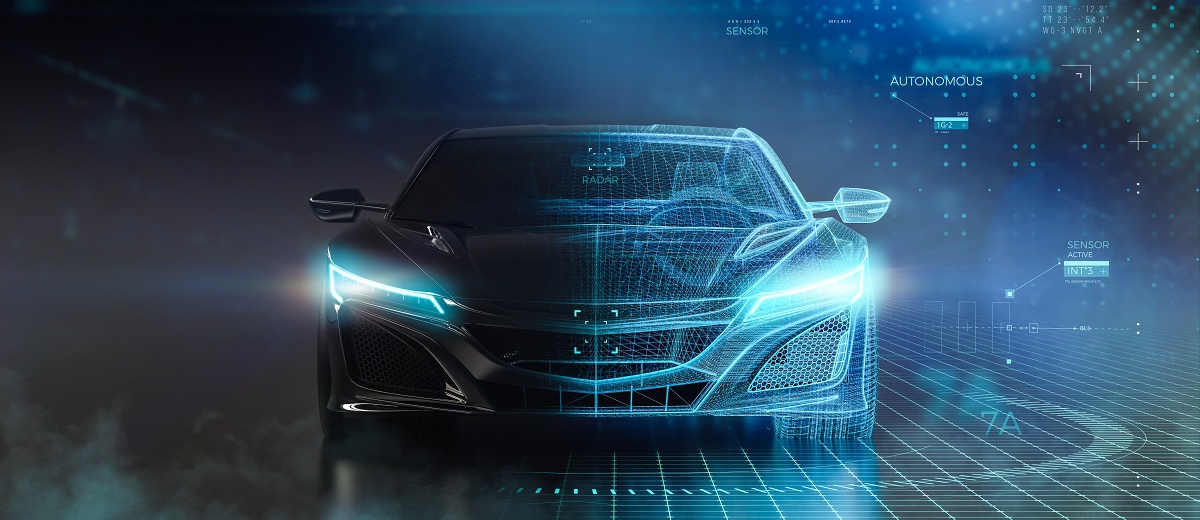
Introduction to C-V2X Technology and Recent FCC Rule Adoption
Cellular Vehicle-to-Everything (C-V2X) is a wireless communication technology that enables vehicles to communicate with 1)each other (V2V), 2)infrastructure (V2I), 3)pedestrians (V2P), and 4)networks (V2N). It is a key component of intelligent transportation systems (ITS) and supports advanced safety and mobility applications for connected and automated vehicles (CAVs) by facilitating low-latency, high-reliability communication between vehicles, infrastructure, pedestrians, and networks. C-V2X enhances situational awareness, improves safety, and enables cooperative driving maneuvers essential for self-driving vehicles.
C-V2X Enhances Autonomous Driving Capabilities
1. Increased Situational Awareness with Non-Line-of-Sight (NLOS) Sensing
- Unlike LiDAR and radar, which rely on direct line-of-sight, C-V2X enables cars to detect hidden hazards, such as:
- A vehicle suddenly braking ahead, even if it's blocked by other cars.
- A pedestrian stepping into the road from behind a parked car.
- An emergency vehicle approaching from a distance, allowing the car to yield early.
2. Low-Latency Communication for Real-Time Decision Making
- C-V2X operates with millisecond-level latency, allowing autonomous cars to:
- React instantly to braking vehicles, road debris, or changing traffic signals.
- Perform cooperative maneuvers, such as synchronized lane changes with nearby autonomous cars.
- Reduce reaction time in emergency situations, improving road safety.
3. Cooperative Driving & Platooning
- Platooning via C-V2X has the following benefits:
- Improved fuel efficiency due to reduced air drag.
- Higher traffic throughput, reducing congestion on highways.
- Safer travel, as vehicles communicate their speed and braking actions in real-time.
4. High-Precision Mapping & Navigation
- Autonomous vehicles rely on HD maps, which require real-time updates.
- C-V2X enables map updates via V2N, providing information about:
- Road closures, detours, and lane restrictions.
- Temporary speed limits due to weather or construction zones.
- Traffic congestion and alternative routes.
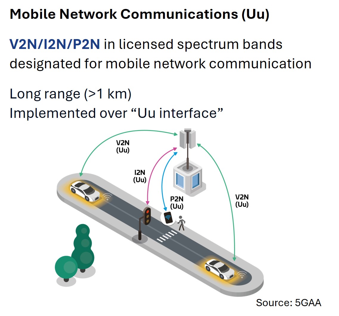
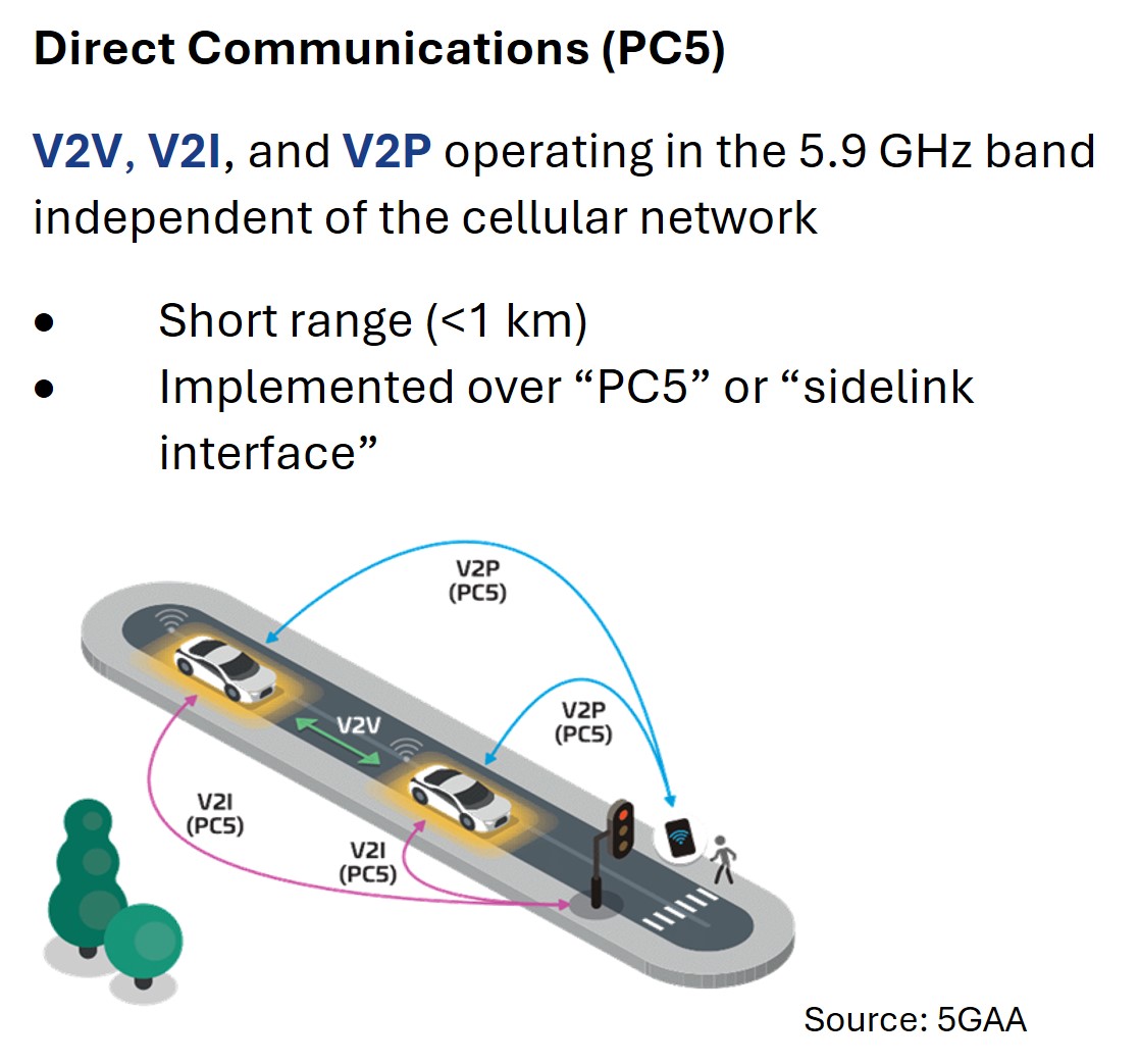
Two Complementary Communication Modes in C-V2X
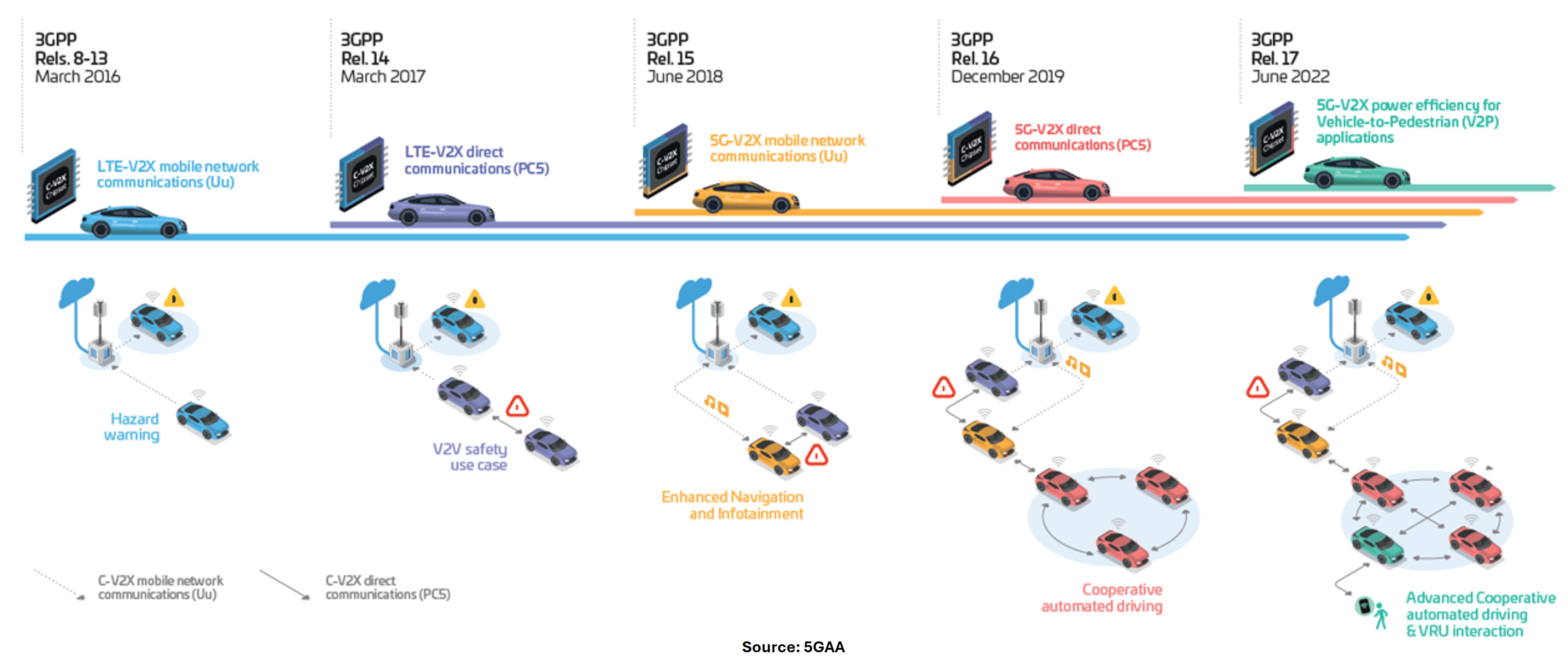
C-V2X Technology Evolution
|
C-V2X vs. Other ADAS Technologies |
||
| Technology | Strengths | Weaknesses |
| C-V2X | NLOS sensing and low-latency communication allow for greater situational awareness and real-time decision-making | Still in early deployment and requires wide adoption |
| LiDAR | High precision in 3D object detection | Struggles in fog, rain, and snow |
| Radar | Works well in adverse weather | Limited object classification ability |
| Cameras | Identifies road signs, lanes, and objects | Requires powerful AI, struggles in low light and fog |
| HD Maps + GPS | Provides global positioning and road layout | Not real-time, can be outdated |
V2X complements ADAS to provide an all-encompassing safety solution for self-driving cars.
Evolution to 5G NR-V2X (3GPP Release 16+)
5G NR-V2X will bring:
- Higher data rates and lower latency for complex driving scenarios.
- Essential for supporting semi-autonomous and fully autonomous Level 4/5 driving.
- Enhanced support for cooperative perception, where vehicles share sensor data in real time.
|
5G NR-V2X vs. Previous V2X Technologies |
|||
| Feature | DSRC | LTE-V2X (Rel. 14) | 5G NR-V2X (Rel. 16+) |
| Latency | ~20-30ms | ~10-20ms | <10ms |
| ReliabilityR | Moderate | High | Ultra-High (99.999%) |
| Data Rate | Low | Moderate | High (for real-time sensor sharing) |
| Range | ~300m | ~500m | >1km |
| Cooperative Perception | Limited | Partial | Full (sensor fusion between vehicles & infrastructure) |
Recent FCC Rule Adoption on C-V2X
On November 20, 2024, the FCC finalized rules, which became effective on February 11, 2025, to fully transition the 5.9 (5.850-5.925) GHz spectrum from Dedicated Short-Range Communications (DSRC) to the C-V2X technology. Key highlights of the FCC's C-V2X rule adoption are as follows:
- The upper 30 MHz portion (5.895-5.925 GHz) was reallocated exclusively to C-V2X. The lower 45 MHz (5.850–5.895 GHz) was allocated for unlicensed Wi-Fi use (Wi-Fi 6E & 7).
- On December 14, 2026, DSRC-based operations will no longer be permitted. Existing DSRC licensees may continue to use DSRC during the transition period, but no new DSRC licenses will be issued after February 11, 2025.
- Established technical requirements in FCC Part 90M for roadside units (RSUs) and FCC Part 95L for onboard units (OBUs).
The FCC's technical requirements for C-V2X differ from DSRC in several key aspects, including spectrum allocation, communication technology, power limits, and channelization. Below is a detailed comparison:
| Feature | C-V2X | DSRC |
| Frequency Band | 5.895–5.925 GHz (30 MHz) | 5.850–5.925 GHz (75 MHz) |
| Max OBU EIRP | Details see below | 33 dBm (2 W) |
| Max RSU EIRP | 33 dBm (2 W) | 44 dBm (25 W) |
| Channelization | 10, 20, or 30 MHz channels | 10 MHz channels |
To allow the OBUs to operate at higher power levels, the FCC has permitted the voluntary use of geofencing capability to enable OBUs to detect appropriate protection areas around federal radiolocation sites to ensure that they operate with lower power levels within such protected areas.
The following power limits apply for OBUs without a geofencing capability at all locations and for OBUs with a geofencing capability when operating within any coordination zone specified in 47 CFR § 90.387(b):
- 10 MHz channel (5895-5905 MHz) and 30 MHz channel: max EIRP 23 dBm.
- 10 MHz channel (5905-5915 and 5915-5925 MHz) and 20 MHz channel (5905-5925 MHz): max EIRP 33 dBm, reduced to 27 dBm within ± 5 degrees of horizontal.
- 20 MHz channel (5895-5915 MHz): max EIRP 23 dBm.
For OBUs with a geofencing capability when operating at locations outside any coordination zone specified in 47 CFR § 90.387(b), the maximum EIRP is 33 dBm for all channel bandwidths.
For an OBU with geofencing capacity to receive FCC approvals, it is required that the applicant submit a narrative describing the geofencing mechanism used. OBUs with geofencing capability are filed under equipment class CVG.
A summary of the FCC geofencing requirements is as follows:
- The geofencing mechanism may be an integrated or a separate GNSS system source that uses a full-time connection and can only be received from US-licensed or approved satellites.
- The expected meter accuracy for one standard deviation or Circular Error Probability (CEP) must be specified.
- The maximum default EIRP must be specified when the OBU cannot retrieve an accurate location fix, which is the same as an OBU without geofencing.
- The OBU must reduce power upon entering a coordination zone. This can be verified by creating a local test coordination zone and radius on the OBU to demonstrate how the OBU lowers its power when entering the test location. The test report must include the time between high and low power versus entry time and power adjustment, and must also list the test coordination zone, the radius used for testing, and the speed at which the device traveled when entering the coordination zone.
- If coordination zones and parameters are subsequently modified or added, a mechanism to update OBUs with the new information shall be provided. All geofenced OBUs shall have internet access to a manufacturer's push service to update coordination zones and parameters if necessary, according to 47 CFR §90.387(b).
With the FCC paving the way to promote the use of the C-V2X technology for the advancement of autonomous driving, we expect to see more and more C-V2X devices proliferate in the American market. Based on our past experiences in certifying DSRC systems, SGS Taiwan is fully equipped and committed to providing the highest quality FCC C-V2X testing and certification services to our customers. Should you be in need of such services, please do not hesitate to contact your SGS sales representative.
📧 twwireless.MKT@sgs.com ☎ (02) 2299-3279 # 1530 / 1522